Imagine that you have 650,000 needles in a haystack. In that pile are some great needles: needles that are very valuable and make many of the other needles more valuable, too. But to find the best needles, you need to sort out every single needle and compare it to every other one. Now imagine that you have built a tool that will do that.
You are getting the picture of what a new Geographic Information System (GIS) developed by the Black Swamp Conservancy is going to do for land conservation and habitat restoration in our community. The new GIS is a multi-layered, nuanced mapping system that links data to specific locations and allows users to visualize new relationships between parcels of land.
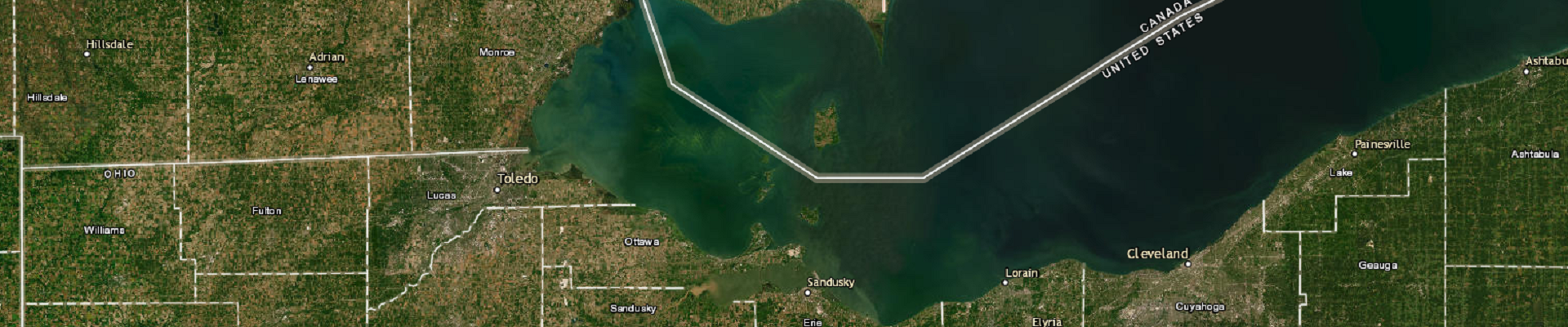
In the span of a year, the Conservancy, working with its technical contractor, GEOACE, collected and recorded data sets that describe features of 650,000 parcels of land in our 14-county service area. We are looking at land that we may be able to put into our protection and trying to target the most valuable places. The data we collected includes information about how often a piece is flooded, whether land is currently farmed or woodland, source of water on the land, how each piece is linked to the other by water or habit, and about 30 other parameters that were separated into five categories. We can turn on and off certain layers of information to make connections between other parameters more apparent. By analyzing this data and seeing how parcels of land relate to each other, we are able to see more clearly where our restoration resources will give us the best return for our investment in improving water quality and expanding wildlife habitat
There were some surprises. Often when we walk a property, we can see that it is connected to a major waterway, or that a frequently flooded farm field is well-suited for restoration to a wetland if we sunlight the drainage tiles and move some dirt. But GIS analysis showed us some jewels that we had not had in our sights. GIS analysis might show us, for example, that if we can protect a corridor of small parcels, we will establish a stronger habitat than if we focused on one large area. Or we might get a hint of the hidden headwaters of a small stream. The GIS gives us a sophisticated scientific tool that is a great help to our boots-on-the-ground reviews.
The Conservancy was selected by the Land Trust Alliance to receive program funding for the GIS as a Great Lakes Water Quality pilot program. MaryKay O’Donnell, midwest conservation manager for the Land Trust Alliance, said, “We recognized that the plan designed by the Black Swamp Conservancy would be valuable far beyond their incredibly important work in the western Lake Erie basin. Their GIS has learning applications that will be valuable for any group working in land restoration.” One of the terms of the funding is that the Conservancy share information with other conservancies in the Midwest and across the country.
O’Donnell pointed to features of the GIS program that make possible a better response to landscape changes. She noted that Black Swamp areas which have been drained and farmed for generations might not currently show great plant diversity or habitat. But the data in the GIS indicate adaptability and restorability: places where wetlands are likely to thrive, and which will protect Lake Erie from excess nutrients by storing water and converting nutrients into native plants.
The GIS is a dynamic system. It will be kept current as new information is acquired and as data sets are updated. Conservancy Executive Director Rob Krain said, “With this information, we are prepared for the future. We are becoming even more effective and ready to take advantage of opportunities.”